The Babylonian Map of the World: Earth’s Oldest Known Cartographic Representation
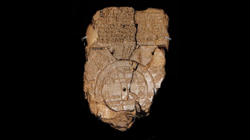
Dating back to the 6th century BCE, the Babylonian Map of the World stands as the oldest known cartographic representation of the Earth. This remarkable artifact, also known as the Imago Mundi, offers a fascinating glimpse into how ancient Babylonians perceived their world over 2,500 years ago.
Discovered in the late 19th century at the archaeological site of Sippar in modern-day Iraq, this clay tablet now resides in the British Museum. Measuring just 12.2 by 8.2 centimeters, the tablet contains a circular map inscribed in cuneiform script, the writing system of ancient Mesopotamia.
The map depicts the world as a flat disc surrounded by a circular ocean, labeled as the “Bitter River.” At the center of this world lies Babylon, straddling the Euphrates River, which flows from north to south. Other identifiable locations include the city of Susa to the south, Urartu to the northeast, and curiously, the Kassite capital of Habban incorrectly placed to the northwest.
Beyond the circular ocean, the map shows seven or eight triangular regions, each labeled as a nagu or “region.” These areas, possibly representing distant mountains, are described in accompanying text as places of mystery and magic. Some descriptions mention lands of perpetual darkness or eternal sunlight, showcasing the blend of geographical knowledge and mythological beliefs characteristic of the era.
The tablet’s obverse side contains text describing the creation of the world by Marduk, the chief god of Babylon. This narrative mentions various animals and mythical creatures, further illustrating the intertwining of cosmology, mythology, and geography in Babylonian thought.
Interestingly, the map bears similarities to another fragment, VAT 12772, which presents a comparable topography from nearly two millennia earlier, suggesting a long-standing tradition of world conceptualization in Mesopotamian culture.
While the Babylonian Map of the World may seem primitive by modern standards, it represents a significant milestone in human understanding of geography and our place in the world. It reflects not just geographical knowledge, but also the cultural, religious, and mythological perspectives of one of the world’s earliest civilizations.


